
How can a warmer North Atlantic Ocean influence the weather in Western Europe?
In the last two years, sea surface temperatures in the North Atlantic have been significantly higher than in previous years reaching near-record and record-breaking temperatures (Copernicus Climate Change Service/ECMWF, 2024). This raises the question of whether and how a warming North Atlantic Ocean can affect large-scale weather patterns in Europe. This question was addressed in our work on a case study in February 2019, which has been started in the Large-scale Dynamics and Predictability working group and was continued as collaboration between the Mesoscale Processes and Predictability and Regional Climate and Weather Hazards working groups.
In this study, we analyze the winter heat records that were set over Western Europe and especially Great Britain during an atmospheric blocking event in February 2019. Prior to this winter heatwave, two strong extratropical cyclones developed over the Gulf Stream, traveled eastwards and influenced the large-scale flow situation over the North Atlantic and European region. Mid-latitude cyclones frequently form in the Gulf Stream region due to large sea surface temperature gradients. To-date it remains unknown how the Gulf Stream absolute sea surface temperature and sea surface temperature gradients can impact cyclone evolution and remotely influence Western European weather patterns.
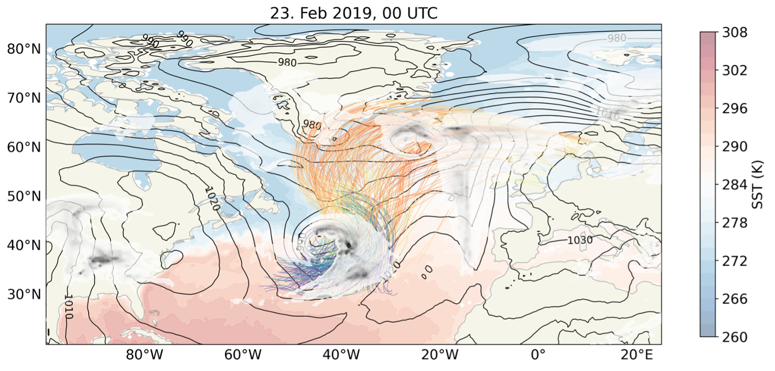
In this study, we specifically investigated how a change in sea surface temperature characteristics in the Gulf Stream region affects the development of cyclones, in particular the strong air mass ascent and cloud formation ahead of the cold front in the so-called “warm conveyor belt” airstream (Fig. 1) which is responsible for the main rainfall in mid-latitude cyclones, and the blocking over Great Britain. For this purpose, we simulated the February 2019 case with the numerical weather forecasting model ICON, which is also used operationally at Deutscher Wetterdienst (DWD). In sensitivity experiments the sea surface temperature in the Gulf Stream region was modified, among others, increased by up to 1.5°C. Additionally, the strong sea surface temperature gradient in the Gulf Stream region was weakened which effectively reduces the mean sea surface temperature experienced by the two cyclones traveling across this region.
The simulations show that after both cyclones passed through the Gulf Stream region, cold and dry air masses from the north are advected across the Gulf stream and thereby warmed and enriched with moisture by the relatively warm underlying sea surface south of the Gulf Stream (see also Wenta et al. 2024). This low-level moisture represents a moisture source for subsequent upward moisture transport during warm conveyor belt ascent starting from the warm sector of the cyclones. Thereby, large-scale cloud bands form through condensation and rain develops during the ascent. Over warmer sea surface temperatures stronger evaporation leads to the development of a moister boundary layer. Our simulations show that in the investigated case study enhanced low-level moisture also results in stronger warm conveyor belt ascent (Fig. 2a, red line), as the air mass ascent in the warm conveyor belt is influenced by latent heat release from cloud formation. Moreover, this results in larger rainfall amount across the North Atlantic. Thus, sea surface temperature characteristics in the Gulf Stream influence the cloud and precipitation characteristics in the North Atlantic region (Fig. 2b, red line).
![]()
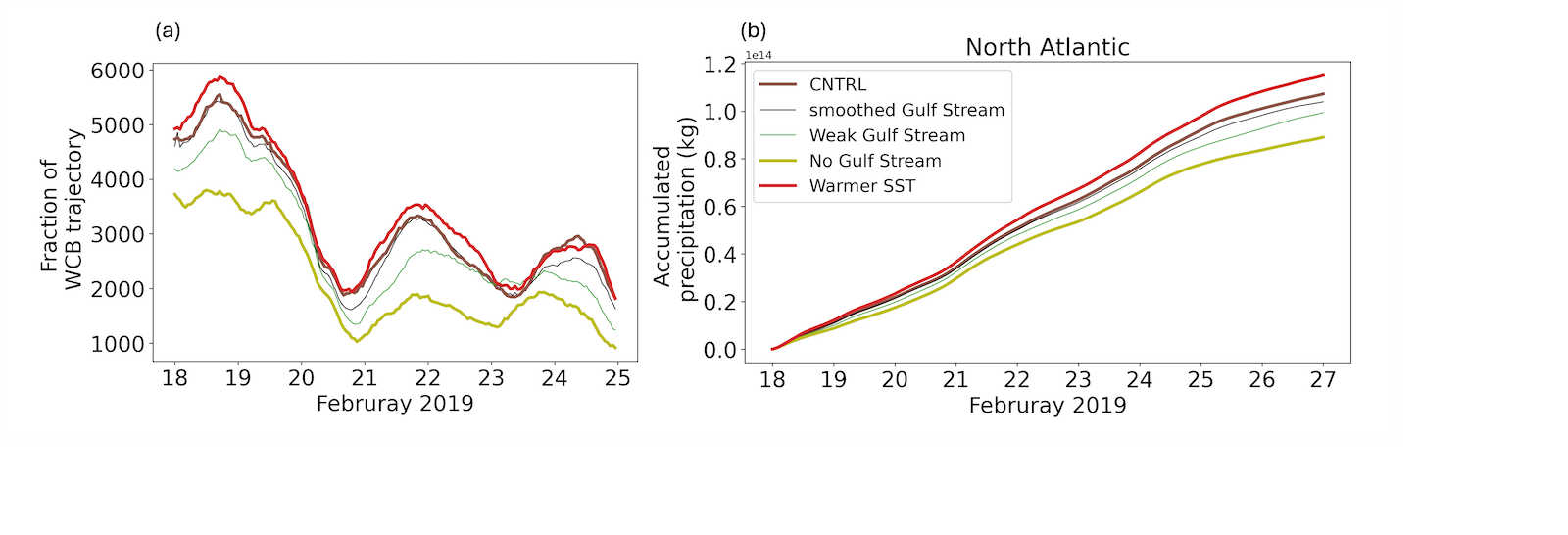
Subsequently, we identify a physical mechanism for the remote influence of Gulf Stream sea surface temperatures on weather further downstream over Europe. The simulations show that the warm conveyor belt interacts with the jet stream in the upper troposphere and amplifies the high pressure system over Western Europe responsible for the record-breaking winter temperature over Great Britain. The interaction between ascending warm conveyor belt air masses and the jet as well as subsequent ridge amplification, are stronger when sea surface temperatures are warmer. Respectively, when sea surface temperature gradients in the Gulf Stream region are smaller and the cyclones effectively pass over colder water, the warm conveyor belt ascent is weaker (Fig. 2a, light green line), and less rain forms (Fig. 2b, light green line). This in turn results in a weaker ridge over Western Europe.
This way, sea surface temperature characteristics in the Western North Atlantic can remotely influence the weather over Europe. Our simulations, therefore, outline how sea surface temperature characteristics in the Western North Atlantic can be linked to the weather situation over Europe. In summary, this study provides detailed insight into the underlying mechanisms for the remote influence of Gulf Stream sea surface temperature characteristics on the large-scale weather pattern over Europe in the specific case of the February 2019 winter heatwave.
Svenja Christ, Marta Wenta, Christian Grams, and Annika Oertel
Copernicus Climate Change Service/ECMWF, 2024: Surface air temperature for June 2024, https://climate.copernicus.eu/surface-air-temperature-june-2024 (last viewed July 2024), 2024
Wenta, M., Grams, C. M., Papritz, L., and Federer, M.: Linking Gulf Stream Air–Sea Interactions to the Exceptional Blocking Episode in
February 2019: A Lagrangian Perspective, Weather and Climate Dynamics, 5, 181–209, https://doi.org/10.5194/wcd-5-181-2024, 2024.