New insights into disagreement between models about tropical rainfall
The intertropical convergence zone (ITCZ) is the main rainfall belt in the tropics. It is a primary contributor to global rainfall and is tightly connected with the meridionally overturning Hadley circulation. The latter redistributes latent heat released by convection in the ITCZ from the tropics to the extratropics, making the ITCZ crucial for the atmospheric energy balance. Unfortunately, large biases in simulating the ITCZ remain in weather and climate models. One potential way to alleviate this problem is to decrease the model grid spacing to few kilometers such that thunderstorms can be represented explicitly, thereby improving multiscale interactions between convection and large-scale circulations. This, however, greatly enhanced the computational cost compared to standard climate models. In a recent study led by Dr. Hyunju Jung, researchers from IMKTRO and the Ludwig Maximilian University in Munich performed sensitivity tests using the ICON model of the German Weather Service (DWD) in a tropical aquachannel configuration, i.e., restricted to low latitudes and without any continents. The model output was analyzed with a novel diagnostic tool based on Emanuel (2019) [1] that helps unveil physical reasons behind differences in mean rainfall due to modifications in grid spacing and the treatment of thunderstorms and other clouds.

The diagnostic framework is based on boundary-layer quasi-equilibrium, the weak temperature gradient approximation, and mass and energy conservation. In boundary-layer quasi-equilibrium, an uptake of energy by the atmosphere from the ocean is balanced by the import of drier and/or cooler air from higher levels through subsidence or sinking motions in the vicinity of thunderstorms, e.g., driven by evaporating rain. A key parameter is the so-called precipitation efficiency, i.e., the fraction of cloud condensate ultimately turned into rain at the surface. “The great innovation about the new framework”, stresses lead author Jung, “is that for the first time it allows for a fair comparison between all simulations despite the different treatment of clouds and thunderstorms.”
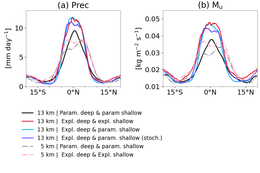
All experiments have a clear rainfall maximum around the equator, similar to the ITCZ over real-world tropical oceans (panel a). However, mean rainfall increases when thunderstorms are explicitly represented (black & gray vs. colored lines), and a finer grid spacing dries and broadens the ITCZ (solid vs. dash-dotted lines). The diagnostic tool of Jung et al. reveals that differences in convective updraft mass flux (panel b) mainly explain the differences in rainfall, while precipitation efficiency changes only little. At 13 km, an explicit representation of thunderstorms produces a stronger large-scale circulation and surface winds, which enhances surface fluxes. The latter extract heat and moisture from the ocean, which is balanced by increased sinking motions, triggered by evaporating rain. When reducing the grid spacing, e.g., from 13 km to 5 km, this wind-surface fluxes-rainfall relation holds with an additional role of a change in air properties, as the vertical gradient in moisture determines how much drier, cooler air is transported downward to lower levels. These results highlight the general utility of the diagnostic tool for a better physical understanding of differences between different weather and climate models and should be used more widely in the research community.
[1] Emanuel, K.: Inferences from simple models of slow, convectively coupled processes, J. Atmos. Sci., 76, 195–208, https://doi.org/10.1175/JAS-D-18-0090.1, 2019.
[2] Jung, H., Knippertz, P., Ruckstuhl, Y., Redl, R., Janjic, T., and Hoose, C.: Understanding the dependence of mean precipitation on convective treatment and horizontal resolution in tropical aquachannel experiments, Weather Clim. Dyn., 4, 1111–1134, https://doi.org/10.5194/wcd-4-1111-2023, 2023.
