AMMA: modelling weather systems of the West African Monsoon and their interaction with the Saharan Air Layer
- Contact: Prof. Dr. S. Jones, N. Lichtenberger, J. Sander
- Project Group:
Modelling and hazard analysis of weather systems
In this contribution to AMMA-EU we investigate the dynamics of African Easterly waves, their embedded convective systems and their transformation to tropical cyclones. We conduct numerical experiments using the Lokal-Modell (LM) of the Deutscher Wetterdienst (DWD). Currently we are assessing the performance of LM over Africa and the eastern Atlantic with a series of simulations in 2004 and the AMMA dry run 2005. Following the SOP we will model selected cases and investigate the interaction with the Saharan Air Layer with the coupled dynamics-aerosol modelling system LM-ART.
Description
 |
|
|
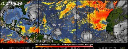
The majority of Atlantic hurricanes develop from African Easterly waves that grow through a mixed barotropic / baroclinic instability on the African Easterly Jet. The transformation from AEW to tropical cyclone depends on a number of factors, including small vertical shear of the horizontal wind and high humidity in the mid-troposphere. Recently it has been proposed that the proximity of a tropical cyclone to the warm, dry and dusty Saharan Air Layer (SAL – Fig. 1) may inhibit its intensification, although the high relative vorticity associated with the SAL may be beneficial for the initial stages of cyclogenesis.
Using LM we have modelled cases in which AEWs developed into tropical cyclones and interacted with the SAL. We have implemented the technique for objective analysis of the AEJ and AEW trough lines of Berry et al. (http://www.atmos.albany.edu/student/gareth/) to analyse the results. An example is given in Fig. 2 in which the jet axis extends from Africa over the Atlantic, several easterly waves are seen and Hurricane Ivan is developing at the southern end of the AEW along 30 W.
We carried out a series of 72 h forecasts initialised at 00 and 12 UTC from 12 August – 06 September 2004. During this period there were a number of AEWs, 3 of which developed into the hurricanes Danielle, Frances and Ivan (Fig. 3). The horizontal resolution was 0.25° with 35 levels. The model area is seen in Fig.2. Initial and boundary conditions were taken from the DWD global analysis. During most of this time period the forecasts of the jet axis location and jet strength were generally good. The forecasts of the AEW trough lines were somewhat less reliable, with some waves being well forecast but others not. The reasons for the varying forecast quality are being investigated. Forecasts of the interaction between the tropical cyclones and the SAL were sensitive to how well LM forecast both the strength and location of the developing tropical cyclone. Given the horizontal resolution used we cannot expect tropical cyclone genesis to be well captured. Future work will use higher resolution nests around the developing tropical cyclone.
|
|
 |
|
|
|
||
 |
|
|

